Method 1:
This method can be used when the Sun doesn't rise very high. This was originally developed for an astronomical exercise in Finland, which lies at a high latitude.
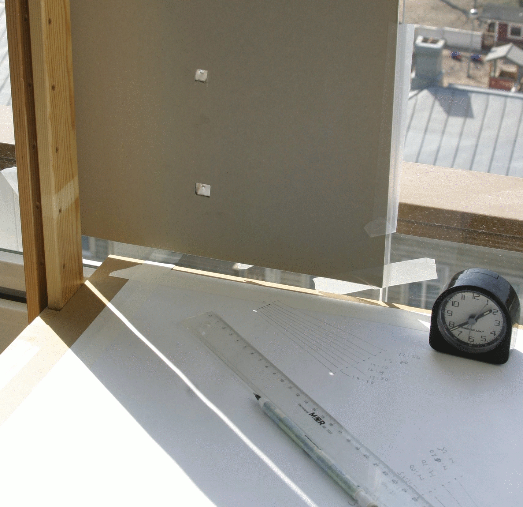
First, find a window through which the Sun will shine during its transit. The window doesn't have to point South; the only important thing is that the Sun is visible through it around noon. Then put a table in front of the window (a window sill might do but it may be too narrow or not exactly horizontal; you should check that with a spirit level). Then you'll need a piece of paper or tin foil, in which you pierce two small holes with a needle. The exact distance of the holes is not important, but you should measure it as precisely as you can. Larger distance will usually give more accurate results. Tape the paper or foil to the window taking care that the holes are aligned exactly vertically. Now the Sun will shine through the holes and there will be two bright spots on the table. To mark the positions of the spots tape a piece of paper on the table.
The transit of the Sun will take place at the local noon. Because our clocks do not show the local time but the time of the nearest time zone, the transit time will differ from 12:00, usually by less than one hour. During the daylight savings time the difference can, however, be almost two hours.
Observations should be started well before the transit of the Sun. In principle we do not know when that will happen, but here we can be a little sloppy and consult an almanac or an astronomical yearbook. Anyway, the Sun will transit around 12 o'clock (or maybe 13 o'clock during daylight savings time). The exact time depends on your position with respect to the parallel of longitude used to determine your official zonal time.
As soon as the light spots hit the paper on the table, mark their positions. It doesn't matter whether you mark the centre or one of the edges, which is easier. What matters is to mark them consistently always in the same manner. Depending on the arrangement you could mark the positions at intervals of a few minutes. The intervals should be pretty accurate, so follow the second hand of your watch. The intervals are important, not the true time. We'll see later how to correct for that.
You will be plotting lots of pairs of points. To keep track of them, draw immediately a line joining the two points belonging to the same instant of time and write the corresponding time next to it.
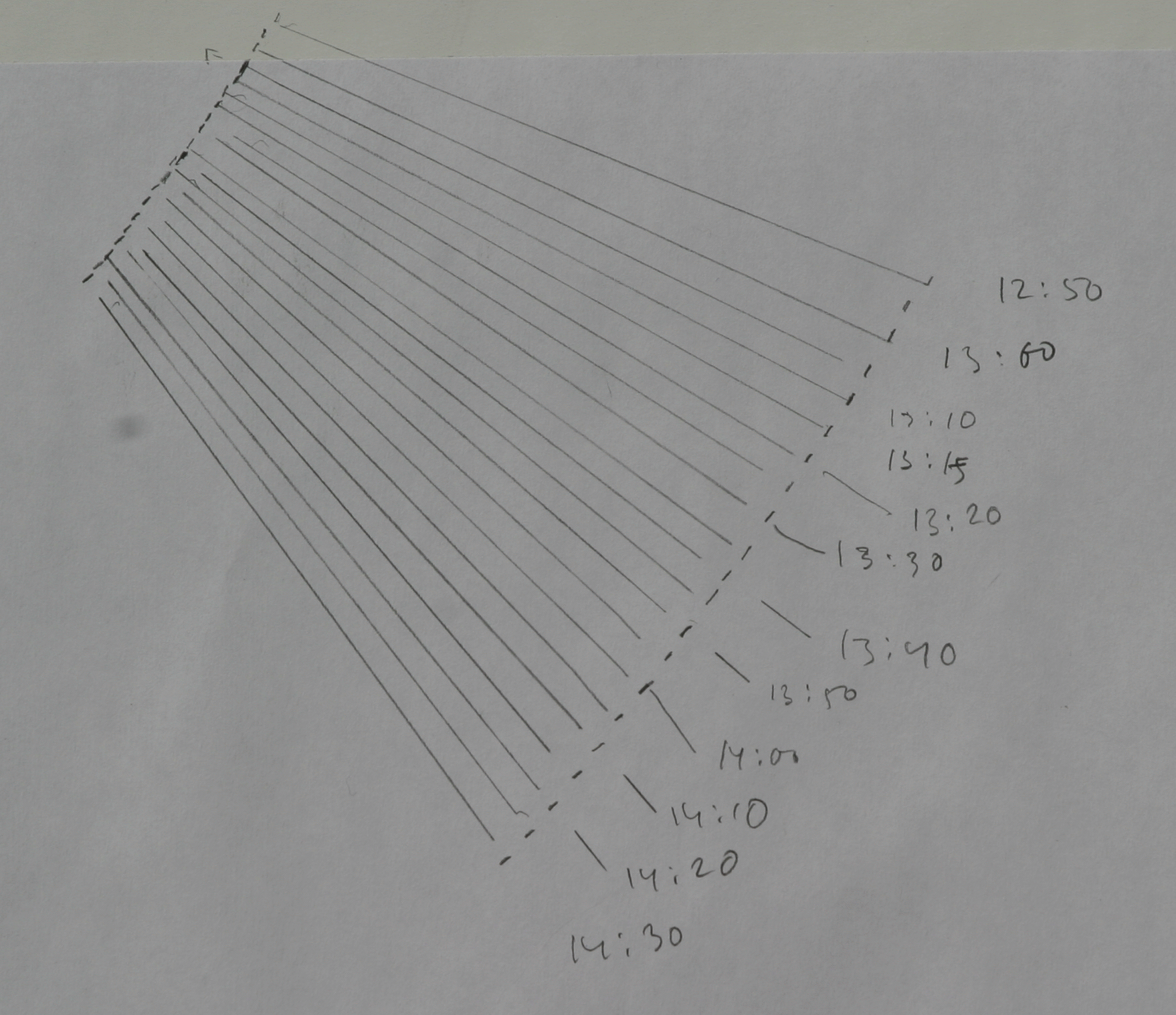
The spots on the paper will approach each other until after the local noon they will begin to diverge. You should continue the observations as long as possible (until the spots move outside the paper).
Now you are ready with the observations. As in most astronomical projects they are just the simple routine part of the work, the tip of the iceberg, so to say. Then comes the analysis, the mathematical part (or the real fun, if you are so inclined).
Practical considerations
Method 2:
Another method is applicable everywhere, but you have to work outside.
Instead of the pinhole images of the Sun use the shadow of any vertical object (a flagpole, lamppost; or erect a rod just for the measurements). It is important that the shadow is cast on a flat horizontal surface. Also the exact length of the object must be known.
As in the previous method, mark the position of the end of the shadow before and after the local noon at a few minute intervals.
Practical considerations
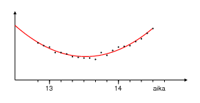
After finishing the observations, measure the distances of each pair
of spots or the lengths of the shadow. Plot the results with time on
the horizontal axis and distance on the vertical axis. The points
should lie on a curve that looks like a parabola. They will not form
an exactly smooth curve; there will be some scatter due to small
inaccuracies in marking the spots and measuring their distances. Don't
worry about this. When there are many observations the small random
errors will cancel out. But if there are points that are really a way
off, discard them.
Next find the lowest point of the curve; it corresponds to
the moment when the Sun reached its highest point on the sky.
You can try to draw a smooth parabolic curve approximating the data.
If you want to obtain higher accuracy, fit a curve
to the data using a least squares method;
a small C program for doing the calculations is
included. To use the program you have to write the time-distance
pairs in a file. The program will calculate a second degree
curve describing the data and write the equation of the curve
and the coordinates of its apex.
See the program file for more details.
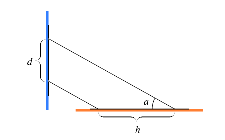
If the distance between the holes in the paper on the window is
d and the shortest distance between the light spots h,
the maximum altitude of the Sun was
a = arctan d/h.
The same formula applies, if d is the length of the pole casting
the shadow and h the length of the shortest shadow.
Method 1:
The declination corresponding to the
time nearest to your observations can be used as a rough
approximation. A more precise value can be found by
interpolation.
Method 2:
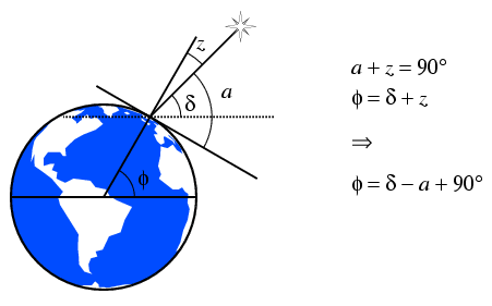
Now we know the altitude a and declination d of the Sun.
The figure below shows that they are related to the latitude
f of the observing site by
f = d - a+ 90\deg.
Altitudes are now obtained directly, and can be plotted
as before. The highest point of the cureve can be estimated
graphically or using a least squares method as before.
Declinations of stars remain fairly constant, and so they
can be looked up in a star catalogue. Again, high precision
means extra work. Catalogues usually give coordinates
for the year 2000. They change slowly mainly due to the
precessional motion of the rotation axis of the Earth.
Depending on the accuracy required also other, smaller
effects may have to be taken into account. The details are
somewhat too complicated to be discussed here. If you
are interested, consult any textbook on spherical astronomy.
The longitude is proportional to the difference of the
local time and UTC. Local time can be determined by
observing the transit time of the Sun or any other object
the coordinates of which are known. The main problem is
that the direction to the South is not known exactly. A compass
cannot be used since it is not very accurate and may suffer
from unknown perturbations. The previously described method
is one way to solve the problem. It is essential to
make several observations before and after the transit,
and also plot the data. It is not sufficient just to follow the
altitude, since at the time of the transit
the altitude does not change, and even close to the transit
the changes are very small, which makes it difficult to
find the maximum precisely. When the curve is plotted,
it is symmetric with respect to the instant of transit,
and can be used to determine the time with high
accuracy, preferably using a least squares program.
For the observations the clock doesn't have to show exactly
correct time, since only the time intervals are important.
To calculate the longitude, however, the time must be known as
exactly as possible. Compare the clock used in the observations
to a time signal e.g. on a radio or to some other clock that
is known to be very accurate. Using this time difference
you can correct the time of the transit. The time signal
tells probably the time of your time zone that usually
differs from the UTC by an integer number of hours.
Find your time zone and use it to calculate the UTC
of the transit.
The time difference to 12 o'clock UTC would give the
longitude if the transit of the Sun took place at 12 o'clock
local time every day. Unfortunately the apparent motion
of the Sun is not quite even. We can see this
in the last column of the solar table
giving the transit time in Greenwich. During the year the
transit time moves around 12:00.
Instead of subtracting 12 from the local time, find the
transit time in Greenwich and subtract it from the local
time. The difference gives the distance from the zero meridian
in time units.
Since one full revolution, 360 degrees, corresponds to 24 hours,
one hour corresponds to 15 degrees. Multiply the time difference
by 15 to get your longitude in degrees.
If the transit took place before 12:00 UTC, the site is
East of Greenwich, if after, the site is West of Greenwich.
The rotation period of the Earth is 24*60 = 1440 minutes.
Thus an error of one minute in the transit time will mean
an error of about 40000/1440 = 28 kilometers on the
equator. Therefore you should be as careful as possible
with time determinations.
Getting a reasonably accurate latitude is not too difficult.
Since the altitude of the Sun changes only slowly, it is much
harder to determine the exact time of the maximum altitude.
Thus the error in the longitude will usually be much larger.
Example: On March 1, 2009, the transit time is 12.2053 hours
and the difference from 12 is 0.2053 hours (12 min 19 sec).
This is also approximately the transit time at our observing site
(not exactly, since the deviation changes with time, but here
we don't care). Thus at the transit time was also 12.2053.
If the observed transit time was 14:30, our watch is
14.5000-12.2053 = 2.2947 hours ahead of the local time.
Later you can use this correction to find the local
time of any other event. Or, even better, you can
adjust your clock so that it will show the local
time directly.
The four Galilean satellites of Jupiter have been used
for this purpose. The method is quite accurate and simple on
solid ground, but on a boat making proper observations is
difficult.
To see the Galilean satellites you will need
binoculars or a telescope. When a satellite orbits Jupiter
it goes through Jupiter's shadow ands seem to disappear.
Depending on the relative positions of the Earth and Jupiter
it is possible to observe either the beginning or end of
the eclipse, but not both. Since the orbital periods of
the Galilean satellites are relatively short (Io 1.769 days,
Europa 3.551 d, Ganymede 7.155 d, and Callisto 16.689 d),
the eclipses are quite frequent.
Times of these events in UTC for the year 2009 are found
in a table here.
In 2009 Jupiter is behind the Sun and therefore invisible at
the end of January. Therefore the table gives only the
events taking place after late spring when observations are
possible.
Now the only thing to do is to observe an event, record
its local time, and look up the UTC in the table. The
time difference in hours, multiplied by 15, gives
the longitude as before.
The theory of motion of the Galilean satellites is quite challenging,
and different versions give slightly different values.
Times given in different sources may vary even by a couple of
minutes. Thus you should not be too disappointed if the
longitude is not very accurate.
1.2 Calculating the altitude of the Sun
1.3 Finding the coordinates of the Sun
Next we have to know the position of the Sun on the celestial sphere.
The coordinate corresponding to the latitude is called declination.
Since the Sun moves with respect to the celestial sphere,
its declination keeps changing. The change is fastest during
vernal and autumnal equinoxes, about 0.4 degrees a day.
During winter and summer solstices the motion in declination
stops and reverses its direction.
The solar coordinates at one day intervals at 0 UTC are found
here. The columns are: year, month, day,
right ascension in hours, declination in degrees, transit time
in UTC at the Greenwich meridian.
You can find the source code of a small C program here.
The program computes the coordinates of the Sun for any moment of time;
hence there is no need for interpolation. The precision, however,
is not quite as high as in the tabulated values that are based
on JPL ephemerides.
1.3 Finding the latitude
2 Finding the latitude with stars
Stars are too faint to be observed in a similar way.
To use stars, you will need a sextant or some other
device for measuring angles. However, they are
pretty expensive. With a sextant an experienced
observer can reach an accuracy of about 10 seconds of arc,
which corresponds to a couple of hundred meters.
Coordinate dials of most small telescopes cannot be read
that accurately, and such instruments cannot be used for
precise latitude determination.
3 Finding the longitude when the UTC is known
Now the latitude is known, and from the same observations
we also get the transit time of the Sun.
This time can be used to calculate the longitude.
4 Finding the local time
We can use the observations to determine also the local
time.
5 Finding the longitude when the UTC is not known
Finding the longitude is based on measuring the difference
between the local time and the time of some fixed
reference place. The problem was very difficult before
radio and accurate clocks. The old pendulum clocks did not
work well on a rolling boat. The marine chronometre
invented by Harrison finally solved the problem.
A different solution, suggested already by Galileo,
is to use celestial events for which the UTC is known.